


Gève/la Sure/la Buffe/pas de la clé. 14km

okfred26
User
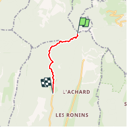

Length
5.4 km

Max alt
1634 m

Uphill gradient
107 m
Km-Effort
7.6 km

Min alt
1294 m

Downhill gradient
344 m
Boucle
No
Creation date :
2019-06-02 12:20:29.333
Updated on :
2019-06-02 14:57:21.718
5h32
Difficulty : Difficult

FREE GPS app for hiking
 SityTrail
IGN / Geographical institutes
SityTrail Plus
The world is yours!
About
Trail Walking of 5.4 km to be discovered at Auvergne-Rhône-Alpes, Isère, Montaud. This trail is proposed by okfred26.
Photos

Positioning
Country:
France
Region :
Auvergne-Rhône-Alpes
Department/Province :
Isère
Municipality :
Montaud
Location:
Unknown
Start:(Dec)
Start:(UTM)
702244 ; 5013111 (31T) N.
Comments