


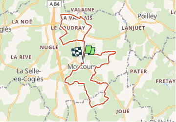
MONTOURS TERRE ROUGE 20Km

COGLAIS3
User

Length
20 km

Max alt
170 m

Uphill gradient
231 m
Km-Effort
23 km

Min alt
118 m

Downhill gradient
235 m
Boucle
Yes
Creation date :
2019-06-04 06:10:27.643
Updated on :
2021-10-11 19:10:32.826
3h40
Difficulty : Very easy

FREE GPS app for hiking
 SityTrail
IGN / Geographical institutes
SityTrail Plus
The world is yours!
About
Trail Nordic walking of 20 km to be discovered at Brittany, Ille-et-Vilaine, Les Portes du Coglais. This trail is proposed by COGLAIS3.
Description
Circuit 20km MONTOURS, terre rouge, MONTOURS
Positioning
Country:
France
Region :
Brittany
Department/Province :
Ille-et-Vilaine
Municipality :
Les Portes du Coglais
Location:
Montours
Start:(Dec)
Start:(UTM)
625199 ; 5367085 (30U) N.
Comments