


Autoire lot Of sports

cps46
User
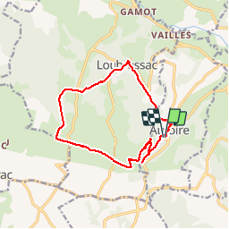

Length
14.7 km

Max alt
418 m

Uphill gradient
447 m
Km-Effort
21 km

Min alt
170 m

Downhill gradient
452 m
Boucle
Yes
Creation date :
2019-05-31 07:57:52.0
Updated on :
2019-06-05 14:47:24.124
5h25
Difficulty : Unknown

FREE GPS app for hiking
 SityTrail
IGN / Geographical institutes
SityTrail Plus
The world is yours!
About
Trail Walking of 14.7 km to be discovered at Occitania, Lot, Autoire. This trail is proposed by cps46.
Photos


Positioning
Country:
France
Region :
Occitania
Department/Province :
Lot
Municipality :
Autoire
Location:
Unknown
Start:(Dec)
Start:(UTM)
406680 ; 4967154 (31T) N.
Comments