


Mouscailou inversé

jdelettrez
User
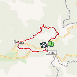

Length
6.1 km

Max alt
808 m

Uphill gradient
219 m
Km-Effort
9 km

Min alt
618 m

Downhill gradient
219 m
Boucle
Yes
Creation date :
2019-06-06 10:19:13.405
Updated on :
2019-06-06 10:21:42.136
1h53
Difficulty : Medium

FREE GPS app for hiking
 SityTrail
IGN / Geographical institutes
SityTrail Plus
The world is yours!
About
Trail Walking of 6.1 km to be discovered at Occitania, Hérault, Rosis. This trail is proposed by jdelettrez.
Description
Petite randonnée par de vieux chemins du col de Madale a la Pierre plantée et Rosis
Positioning
Country:
France
Region :
Occitania
Department/Province :
Hérault
Municipality :
Rosis
Location:
Unknown
Start:(Dec)
Start:(UTM)
501664 ; 4829525 (31T) N.
Comments