


20190606-Boves

doudet
User
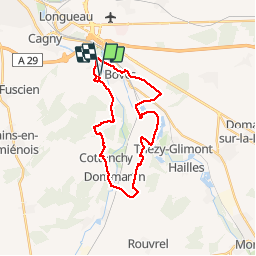

Length
24 km

Max alt
103 m

Uphill gradient
306 m
Km-Effort
28 km

Min alt
23 m

Downhill gradient
308 m
Boucle
Yes
Creation date :
2019-06-06 07:32:09.17
Updated on :
2019-06-18 06:32:08.81
6h31
Difficulty : Medium

FREE GPS app for hiking
 SityTrail
IGN / Geographical institutes
SityTrail Plus
The world is yours!
About
Trail Walking of 24 km to be discovered at Hauts-de-France, Somme, Boves. This trail is proposed by doudet.
Description
Boucle A-R au départ de l'Eglise de Boves
Positioning
Country:
France
Region :
Hauts-de-France
Department/Province :
Somme
Municipality :
Boves
Location:
Unknown
Start:(Dec)
Start:(UTM)
455420 ; 5521622 (31U) N.
Comments
Belle randonnée dans un secteur très vallonné et très varié. Moins de goudron aurait été formidable.