


Le long du canal et de l'Yonne à partir de Joigny

c.chehere
User
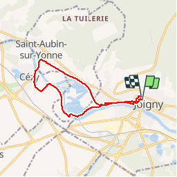

Length
11.3 km

Max alt
111 m

Uphill gradient
95 m
Km-Effort
12.6 km

Min alt
69 m

Downhill gradient
96 m
Boucle
Yes
Creation date :
2019-06-07 05:49:47.777
Updated on :
2019-06-07 06:03:19.604
2h47
Difficulty : Easy

FREE GPS app for hiking
 SityTrail
IGN / Geographical institutes
SityTrail Plus
The world is yours!
About
Trail Walking of 11.3 km to be discovered at Bourgogne-Franche-Comté, Yonne, Joigny. This trail is proposed by c.chehere.
Description
Parking sur les promenades au niveau de la porte des bois
Positioning
Country:
France
Region :
Bourgogne-Franche-Comté
Department/Province :
Yonne
Municipality :
Joigny
Location:
Unknown
Start:(Dec)
Start:(UTM)
529552 ; 5314685 (31T) N.
Comments