


Merens-les-vals -> refuge de bésines

raphael94
User
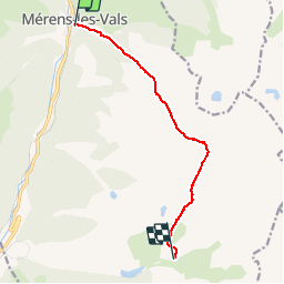

Length
8.7 km

Max alt
2334 m

Uphill gradient
1280 m
Km-Effort
22 km

Min alt
1074 m

Downhill gradient
256 m
Boucle
No
Creation date :
2019-06-07 07:23:42.846
Updated on :
2019-06-09 06:06:18.353
5h50
Difficulty : Easy

FREE GPS app for hiking
 SityTrail
IGN / Geographical institutes
SityTrail Plus
The world is yours!
About
Trail Walking of 8.7 km to be discovered at Occitania, Ariège, Mérens-les-Vals. This trail is proposed by raphael94.
Positioning
Country:
France
Region :
Occitania
Department/Province :
Ariège
Municipality :
Mérens-les-Vals
Location:
Unknown
Start:(Dec)
Start:(UTM)
404727 ; 4723391 (31T) N.
Comments