


St Hubert 09.06.2019

fra_depoorter
User
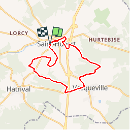

Length
14 km

Max alt
540 m

Uphill gradient
299 m
Km-Effort
18 km

Min alt
390 m

Downhill gradient
301 m
Boucle
Yes
Creation date :
2019-06-09 07:09:12.335
Updated on :
2019-06-09 11:56:30.747
3h11
Difficulty : Easy

FREE GPS app for hiking
 SityTrail
IGN / Geographical institutes
SityTrail Plus
The world is yours!
About
Trail Walking of 14 km to be discovered at Wallonia, Luxembourg, Saint-Hubert. This trail is proposed by fra_depoorter.
Positioning
Country:
Belgium
Region :
Wallonia
Department/Province :
Luxembourg
Municipality :
Saint-Hubert
Location:
Saint-Hubert
Start:(Dec)
Start:(UTM)
669747 ; 5544119 (31U) N.
Comments