


Bruno Corrèze 2

maginot
User
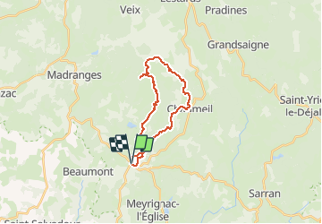

Length
22 km

Max alt
906 m

Uphill gradient
566 m
Km-Effort
30 km

Min alt
560 m

Downhill gradient
565 m
Boucle
Yes
Creation date :
2014-12-10 00:00:00.0
Updated on :
2014-12-10 00:00:00.0
2h31
Difficulty : Difficult

FREE GPS app for hiking
 SityTrail
IGN / Geographical institutes
SityTrail Plus
The world is yours!
About
Trail Mountain bike of 22 km to be discovered at New Aquitaine, Corrèze, Saint-Augustin. This trail is proposed by maginot.
Description
Super sortie monte Monedieres dur et technique descente formidable beau chemin retour sur chaumeil et st Augustin
Photos


Positioning
Country:
France
Region :
New Aquitaine
Department/Province :
Corrèze
Municipality :
Saint-Augustin
Location:
Unknown
Start:(Dec)
Start:(UTM)
408898 ; 5030890 (31T) N.
Comments