


Cime de L ASPRE

trailer.nono
User
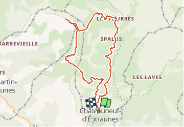

Length
20 km

Max alt
2449 m

Uphill gradient
1301 m
Km-Effort
38 km

Min alt
1263 m

Downhill gradient
1304 m
Boucle
Yes
Creation date :
2019-06-09 07:23:39.384
Updated on :
2019-06-09 17:24:50.482
5h19
Difficulty : Easy

FREE GPS app for hiking
 SityTrail
IGN / Geographical institutes
SityTrail Plus
The world is yours!
About
Trail Walking of 20 km to be discovered at Provence-Alpes-Côte d'Azur, Maritime Alps, Châteauneuf-d'Entraunes. This trail is proposed by trailer.nono.
Positioning
Country:
France
Region :
Provence-Alpes-Côte d'Azur
Department/Province :
Maritime Alps
Municipality :
Châteauneuf-d'Entraunes
Location:
Unknown
Start:(Dec)
Start:(UTM)
326476 ; 4888528 (32T) N.
Comments