Randonnee-Pic-de-Carlit-2921m-Mariano-le-09-09-2013

UDGI54
User
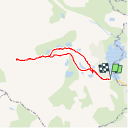

Length
13.4 km

Max alt
2885 m

Uphill gradient
889 m
Km-Effort
25 km

Min alt
2038 m

Downhill gradient
887 m
Boucle
Yes
Creation date :
2019-06-11 07:21:55.866
Updated on :
2019-06-11 07:26:31.929
5h04
Difficulty : Very difficult

FREE GPS app for hiking
 SityTrail
IGN / Geographical institutes
SityTrail Plus
The world is yours!
About
Trail Walking of 13.4 km to be discovered at Occitania, Pyrénées-Orientales, Angoustrine-Villeneuve-des-Escaldes. This trail is proposed by UDGI54.
Points of interest


Positioning
Country:
France
Region :
Occitania
Department/Province :
Pyrénées-Orientales
Municipality :
Angoustrine-Villeneuve-des-Escaldes
Location:
Unknown
Start:(Dec)
Start:(UTM)
417598 ; 4712439 (31T) N.
Comments