Theurey (Barizey)

LUCIE2016
User
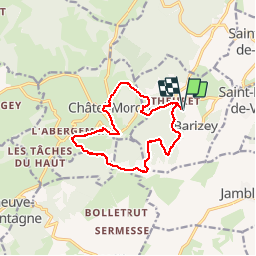

Length
12.4 km

Max alt
485 m

Uphill gradient
364 m
Km-Effort
17.3 km

Min alt
271 m

Downhill gradient
364 m
Boucle
Yes
Creation date :
2019-06-11 11:53:20.436
Updated on :
2019-06-11 14:52:47.381
2h55
Difficulty : Very easy

FREE GPS app for hiking
 SityTrail
IGN / Geographical institutes
SityTrail Plus
The world is yours!
About
Trail Walking of 12.4 km to be discovered at Bourgogne-Franche-Comté, Saône-et-Loire, Barizey. This trail is proposed by LUCIE2016.
Positioning
Country:
France
Region :
Bourgogne-Franche-Comté
Department/Province :
Saône-et-Loire
Municipality :
Barizey
Location:
Unknown
Start:(Dec)
Start:(UTM)
627642 ; 5183471 (31T) N.
Comments