16 EUVILLE Carriére AMl: 07 AVR 2014 14:03

ZAMBAUX
User
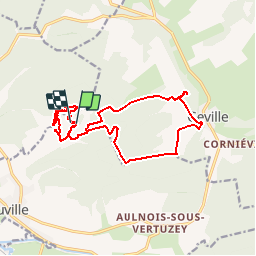

Length
16.9 km

Max alt
368 m

Uphill gradient
335 m
Km-Effort
21 km

Min alt
279 m

Downhill gradient
337 m
Boucle
Yes
Creation date :
2019-06-11 19:38:46.589
Updated on :
2019-06-11 20:20:36.563
4h36
Difficulty : Very difficult

FREE GPS app for hiking
 SityTrail
IGN / Geographical institutes
SityTrail Plus
The world is yours!
About
Trail Walking of 16.9 km to be discovered at Grand Est, Meuse, Euville. This trail is proposed by ZAMBAUX.
Description
Ludres marche
Positioning
Country:
France
Region :
Grand Est
Department/Province :
Meuse
Municipality :
Euville
Location:
Unknown
Start:(Dec)
Start:(UTM)
694565 ; 5405192 (31U) N.
Comments