


SityTrail - AérodromeCernyS300815

c.chehere
User
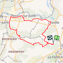

Length
16.7 km

Max alt
153 m

Uphill gradient
270 m
Km-Effort
20 km

Min alt
53 m

Downhill gradient
271 m
Boucle
Yes
Creation date :
2019-06-12 08:09:17.056
Updated on :
2019-06-12 15:20:47.323
4h24
Difficulty : Very difficult

FREE GPS app for hiking
 SityTrail
IGN / Geographical institutes
SityTrail Plus
The world is yours!
About
Trail Walking of 16.7 km to be discovered at Ile-de-France, Essonne, Cerny. This trail is proposed by c.chehere.
Description
Parking à l'aérodrome
Positioning
Country:
France
Region :
Ile-de-France
Department/Province :
Essonne
Municipality :
Cerny
Location:
Unknown
Start:(Dec)
Start:(UTM)
451346 ; 5371556 (31U) N.
Comments