


Lavacherie 13 juin 2019

pierlan
User
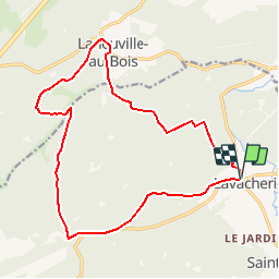

Length
16.4 km

Max alt
594 m

Uphill gradient
451 m
Km-Effort
22 km

Min alt
372 m

Downhill gradient
456 m
Boucle
Yes
Creation date :
2019-06-12 18:56:03.383
Updated on :
2019-06-12 18:58:51.831
4h45
Difficulty : Very difficult

FREE GPS app for hiking
 SityTrail
IGN / Geographical institutes
SityTrail Plus
The world is yours!
About
Trail Walking of 16.4 km to be discovered at Wallonia, Luxembourg, Sainte-Ode. This trail is proposed by pierlan.
Positioning
Country:
Belgium
Region :
Wallonia
Department/Province :
Luxembourg
Municipality :
Sainte-Ode
Location:
Lavacherie
Start:(Dec)
Start:(UTM)
679749 ; 5547551 (31U) N.
Comments