


08082013

fredodlageo
User
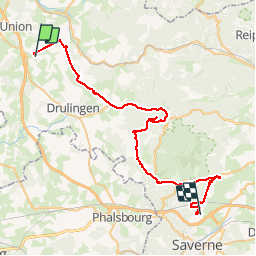

Length
47 km

Max alt
395 m

Uphill gradient
906 m
Km-Effort
60 km

Min alt
185 m

Downhill gradient
991 m
Boucle
No
Creation date :
2014-12-10 00:00:00.0
Updated on :
2014-12-10 00:00:00.0
2h37
Difficulty : Difficult

FREE GPS app for hiking
 SityTrail
IGN / Geographical institutes
SityTrail Plus
The world is yours!
About
Trail Mountain bike of 47 km to be discovered at Grand Est, Bas-Rhin, Thal-Drulingen. This trail is proposed by fredodlageo.
Description
Tmv
Positioning
Country:
France
Region :
Grand Est
Department/Province :
Bas-Rhin
Municipality :
Thal-Drulingen
Location:
Unknown
Start:(Dec)
Start:(UTM)
363700 ; 5419440 (32U) N.
Comments