


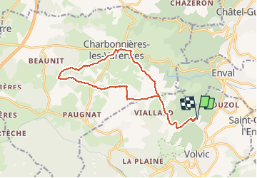
Tournoel Charbonnières les Brossons

Gegetop
User

Length
16.1 km

Max alt
804 m

Uphill gradient
332 m
Km-Effort
21 km

Min alt
586 m

Downhill gradient
332 m
Boucle
Yes
Creation date :
2019-06-13 08:31:18.242
Updated on :
2020-01-17 10:00:08.439
3h48
Difficulty : Medium

FREE GPS app for hiking
 SityTrail
IGN / Geographical institutes
SityTrail Plus
The world is yours!
About
Trail Nordic walking of 16.1 km to be discovered at Auvergne-Rhône-Alpes, Puy-de-Dôme, Volvic. This trail is proposed by Gegetop.
Positioning
Country:
France
Region :
Auvergne-Rhône-Alpes
Department/Province :
Puy-de-Dôme
Municipality :
Volvic
Location:
Unknown
Start:(Dec)
Start:(UTM)
502919 ; 5081210 (31T) N.
Comments