


V 2019 23 & 25-06-Bouilland

clabidault
User
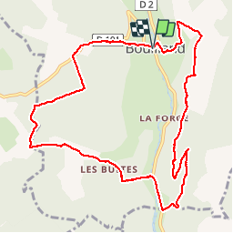

Length
11.5 km

Max alt
591 m

Uphill gradient
417 m
Km-Effort
17.1 km

Min alt
351 m

Downhill gradient
417 m
Boucle
Yes
Creation date :
2019-06-13 12:04:36.361
Updated on :
2019-06-19 06:02:10.185
3h22
Difficulty : Difficult

FREE GPS app for hiking
 SityTrail
IGN / Geographical institutes
SityTrail Plus
The world is yours!
About
Trail Walking of 11.5 km to be discovered at Bourgogne-Franche-Comté, Côte-d'Or, Bouilland. This trail is proposed by clabidault.
Positioning
Country:
France
Region :
Bourgogne-Franche-Comté
Department/Province :
Côte-d'Or
Municipality :
Bouilland
Location:
Unknown
Start:(Dec)
Start:(UTM)
634674 ; 5221461 (31T) N.
Comments
On ne peut plus passer entre sainte marguerite, roche percée et la D2