


bonnet rouge

losjo
User
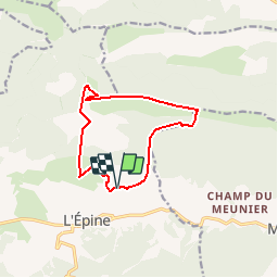

Length
11.6 km

Max alt
1635 m

Uphill gradient
919 m
Km-Effort
24 km

Min alt
850 m

Downhill gradient
918 m
Boucle
Yes
Creation date :
2019-06-13 07:20:08.765
Updated on :
2019-06-13 19:18:14.679
7h07
Difficulty : Difficult

FREE GPS app for hiking
 SityTrail
IGN / Geographical institutes
SityTrail Plus
The world is yours!
About
Trail Walking of 11.6 km to be discovered at Provence-Alpes-Côte d'Azur, Hautes-Alpes, L'Épine. This trail is proposed by losjo.
Positioning
Country:
France
Region :
Provence-Alpes-Côte d'Azur
Department/Province :
Hautes-Alpes
Municipality :
L'Épine
Location:
Unknown
Start:(Dec)
Start:(UTM)
709009 ; 4922359 (31T) N.
Comments