Trail Mountain bike Saint-Augustin - Bruno Corrèze 3 - Photo
 maginot
maginot

User

© OpenStreetMap contributors
Length
Length
32 km
Max alt
Max alt
893 m
Uphill gradient
Uphill gradient
771 m
Km-Effort
Km-Effort  
42 km
Min alt
Min alt
529 m
Downhill gradient
Downhill gradient
716 m
Boucle
Boucle
No
Creation date :
2014-12-10 00:00:00.0
Updated on :
2014-12-10 00:00:00.0

(0 Reviews)

Mountain bike
Mountain bike
2h52
Difficulty : Medium

Scan this QR Code to open this trail in the SityTrail application

FREE GPS app for hiking

Logo SityTrail SityTrail

IGN / Geographical institutes

Download SityTrail from the App Store Download SityTrail from Google Play

Logo SityTrail SityTrail Plus

The world is yours!

Download SityTrail from the App Store Download SityTrail from Google Play Download SityTrail on Huawei AppGallery

About

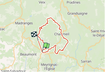
Trail Mountain bike of 32 km to be discovered at New Aquitaine, Corrèze, Saint-Augustin. This trail is proposed by maginot.

Description

Parcours fabuleux monte du col des Monedieres par Chauzeix super monter difficile mais très varié technique sur la fin mais quel récompense en haut puis descente sur chaumeil le top retour pa chemin Barbasange et Tourondel puis route qu a ST Augustin météo parfaite

Elevation profile

Positioning

Country:
France
Region :
New Aquitaine
Department/Province :
Corrèze
Municipality :
Saint-Augustin
Location:
Unknown
Start:(UTM)
408889 ; 5030911 (31T) N.


Close
My subscriptions