


SityTrail - Pic de Cimet etPerdrix

c.chehere
User
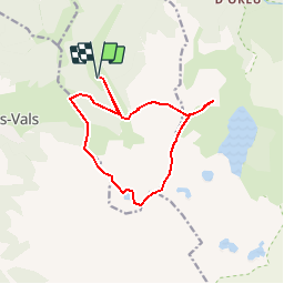

Length
13.7 km

Max alt
2464 m

Uphill gradient
1588 m
Km-Effort
35 km

Min alt
1415 m

Downhill gradient
1588 m
Boucle
Yes
Creation date :
2019-06-14 15:35:43.214
Updated on :
2019-06-14 15:47:23.009
6h43
Difficulty : Difficult

FREE GPS app for hiking
 SityTrail
IGN / Geographical institutes
SityTrail Plus
The world is yours!
About
Trail Walking of 13.7 km to be discovered at Occitania, Ariège, Orgeix. This trail is proposed by c.chehere.
Description
Parking à la cabane des Cizarols
Positioning
Country:
France
Region :
Occitania
Department/Province :
Ariège
Municipality :
Orgeix
Location:
Unknown
Start:(Dec)
Start:(UTM)
407578 ; 4724560 (31T) N.
Comments