


Villefranche de lauragais

FLOCON
User
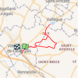

Length
11.8 km

Max alt
266 m

Uphill gradient
183 m
Km-Effort
14.3 km

Min alt
178 m

Downhill gradient
183 m
Boucle
Yes
Creation date :
2019-06-17 06:58:42.657
Updated on :
2019-06-17 10:03:00.445
3h02
Difficulty : Medium

FREE GPS app for hiking
 SityTrail
IGN / Geographical institutes
SityTrail Plus
The world is yours!
About
Trail Walking of 11.8 km to be discovered at Occitania, Haute-Garonne, Villefranche-de-Lauragais. This trail is proposed by FLOCON.
Positioning
Country:
France
Region :
Occitania
Department/Province :
Haute-Garonne
Municipality :
Villefranche-de-Lauragais
Location:
Unknown
Start:(Dec)
Start:(UTM)
396159 ; 4805631 (31T) N.
Comments