


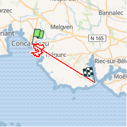
Concarneau

janussity
User

Length
32 km

Max alt
45 m

Uphill gradient
286 m
Km-Effort
36 km

Min alt
-3 m

Downhill gradient
267 m
Boucle
No
Creation date :
2019-06-17 07:38:54.526
Updated on :
2019-06-17 17:23:27.085
7h08
Difficulty : Medium

FREE GPS app for hiking
 SityTrail
IGN / Geographical institutes
SityTrail Plus
The world is yours!
About
Trail Walking of 32 km to be discovered at Brittany, Finistère, Concarneau. This trail is proposed by janussity.
Description
Beau temps
traversée de lotissement
un peu de sentier cotier
Photos


33 photos in total. Please click on a photo to see them all in the gallery.
Positioning
Country:
France
Region :
Brittany
Department/Province :
Finistère
Municipality :
Concarneau
Location:
Unknown
Start:(Dec)
Start:(UTM)
431465 ; 5302433 (30T) N.
Comments