


A - Aller pere Hilarion

randolea
User
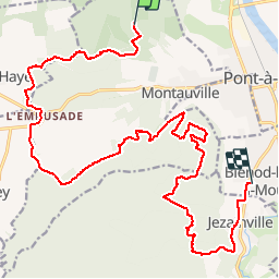

Length
22 km

Max alt
366 m

Uphill gradient
279 m
Km-Effort
26 km

Min alt
186 m

Downhill gradient
403 m
Boucle
No
Creation date :
2019-06-17 21:19:53.845
Updated on :
2019-06-17 21:23:59.213

FREE GPS app for hiking
 SityTrail
IGN / Geographical institutes
SityTrail Plus
The world is yours!
About
Trail of 22 km to be discovered at Grand Est, Meurthe-et-Moselle, Montauville. This trail is proposed by randolea.
Positioning
Country:
France
Region :
Grand Est
Department/Province :
Meurthe-et-Moselle
Municipality :
Montauville
Location:
Unknown
Start:(Dec)
Start:(UTM)
280744 ; 5422170 (32U) N.
Comments