Chemin des fourches

CANON2
User
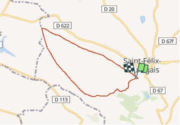

Length
7.1 km

Max alt
325 m

Uphill gradient
117 m
Km-Effort
8.7 km

Min alt
241 m

Downhill gradient
115 m
Boucle
Yes
Creation date :
2019-06-18 05:02:16.991
Updated on :
2019-06-18 05:03:06.403
1h53
Difficulty : Medium

FREE GPS app for hiking
 SityTrail
IGN / Geographical institutes
SityTrail Plus
The world is yours!
About
Trail Walking of 7.1 km to be discovered at Occitania, Haute-Garonne, Saint-Félix-Lauragais. This trail is proposed by CANON2.
Positioning
Country:
France
Region :
Occitania
Department/Province :
Haute-Garonne
Municipality :
Saint-Félix-Lauragais
Location:
Unknown
Start:(Dec)
Start:(UTM)
409829 ; 4810889 (31T) N.
Comments