


autour de Dourgne

CANON2
User
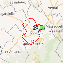

Length
9.5 km

Max alt
295 m

Uphill gradient
103 m
Km-Effort
10.9 km

Min alt
208 m

Downhill gradient
108 m
Boucle
Yes
Creation date :
2019-06-18 06:14:33.186
Updated on :
2019-06-18 06:15:19.087
2h23
Difficulty : Medium

FREE GPS app for hiking
 SityTrail
IGN / Geographical institutes
SityTrail Plus
The world is yours!
About
Trail Walking of 9.5 km to be discovered at Occitania, Tarn, Dourgne. This trail is proposed by CANON2.
Positioning
Country:
France
Region :
Occitania
Department/Province :
Tarn
Municipality :
Dourgne
Location:
Unknown
Start:(Dec)
Start:(UTM)
430386 ; 4815028 (31T) N.
Comments