


grolay mardi

coglais
User
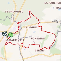

Length
9.3 km

Max alt
187 m

Uphill gradient
181 m
Km-Effort
11.7 km

Min alt
110 m

Downhill gradient
179 m
Boucle
Yes
Creation date :
2019-06-18 07:17:07.129
Updated on :
2019-06-18 10:25:56.912
2h19
Difficulty : Very easy

FREE GPS app for hiking
 SityTrail
IGN / Geographical institutes
SityTrail Plus
The world is yours!
About
Trail Nordic walking of 9.3 km to be discovered at Brittany, Ille-et-Vilaine, Fougères. This trail is proposed by coglais.
Positioning
Country:
France
Region :
Brittany
Department/Province :
Ille-et-Vilaine
Municipality :
Fougères
Location:
Unknown
Start:(Dec)
Start:(UTM)
634448 ; 5358124 (30U) N.
Comments