


arsel 18/6/19 valquieres

labarone
User
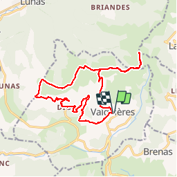

Length
19 km

Max alt
682 m

Uphill gradient
491 m
Km-Effort
26 km

Min alt
310 m

Downhill gradient
490 m
Boucle
Yes
Creation date :
2019-06-18 06:51:44.397
Updated on :
2019-06-18 14:09:18.202
4h58
Difficulty : Easy

FREE GPS app for hiking
 SityTrail
IGN / Geographical institutes
SityTrail Plus
The world is yours!
About
Trail Walking of 19 km to be discovered at Occitania, Hérault, Dio-et-Valquières. This trail is proposed by labarone.
Description
Jusqu à la chapelle St amans
Positioning
Country:
France
Region :
Occitania
Department/Province :
Hérault
Municipality :
Dio-et-Valquières
Location:
Unknown
Start:(Dec)
Start:(UTM)
518945 ; 4834949 (31T) N.
Comments