


Bruno Corrèze 4

maginot
User

Length
33 km

Max alt
562 m

Uphill gradient
671 m
Km-Effort
43 km

Min alt
378 m

Downhill gradient
728 m
Boucle
No
Creation date :
2014-12-10 00:00:00.0
Updated on :
2014-12-10 00:00:00.0
3h13
Difficulty : Difficult

FREE GPS app for hiking
 SityTrail
IGN / Geographical institutes
SityTrail Plus
The world is yours!
About
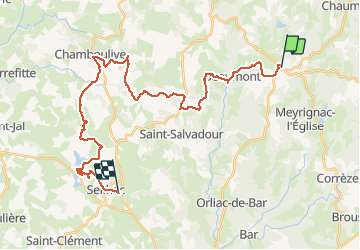
Trail Mountain bike of 33 km to be discovered at New Aquitaine, Corrèze, Saint-Augustin. This trail is proposed by maginot.
Description
Monte sur Beaumont très difficile parcours avec un peu de routier sur la fin très beau temps idéal casse chaîne monte seilhac heureusement près de l arrive
Photos

Positioning
Country:
France
Region :
New Aquitaine
Department/Province :
Corrèze
Municipality :
Saint-Augustin
Location:
Unknown
Start:(Dec)
Start:(UTM)
408879 ; 5030869 (31T) N.
Comments