


malemort du comtat

gnortier
User
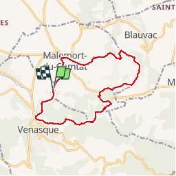

Length
15 km

Max alt
347 m

Uphill gradient
308 m
Km-Effort
19.2 km

Min alt
178 m

Downhill gradient
312 m
Boucle
Yes
Creation date :
2019-06-19 08:34:26.834
Updated on :
2019-06-19 13:16:21.397
4h25
Difficulty : Medium

FREE GPS app for hiking
 SityTrail
IGN / Geographical institutes
SityTrail Plus
The world is yours!
About
Trail Walking of 15 km to be discovered at Provence-Alpes-Côte d'Azur, Vaucluse, Venasque. This trail is proposed by gnortier.
Positioning
Country:
France
Region :
Provence-Alpes-Côte d'Azur
Department/Province :
Vaucluse
Municipality :
Venasque
Location:
Unknown
Start:(Dec)
Start:(UTM)
672711 ; 4875359 (31T) N.
Comments