


SARE - 1

CANON2
User
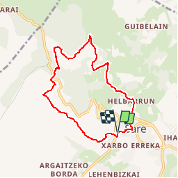

Length
7.9 km

Max alt
275 m

Uphill gradient
379 m
Km-Effort
12.9 km

Min alt
55 m

Downhill gradient
372 m
Boucle
Yes
Creation date :
2019-06-20 14:44:37.792
Updated on :
2019-06-20 14:52:03.54
2h08
Difficulty : Medium

FREE GPS app for hiking
 SityTrail
IGN / Geographical institutes
SityTrail Plus
The world is yours!
About
Trail Walking of 7.9 km to be discovered at New Aquitaine, Pyrénées-Atlantiques, Sare. This trail is proposed by CANON2.
Positioning
Country:
France
Region :
New Aquitaine
Department/Province :
Pyrénées-Atlantiques
Municipality :
Sare
Location:
Unknown
Start:(Dec)
Start:(UTM)
614846 ; 4796454 (30T) N.
Comments