


Le camp d'Arbonne

c.chehere
User
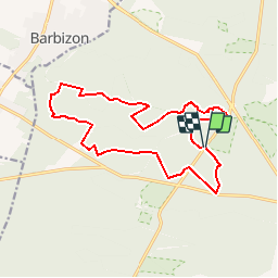

Length
15.3 km

Max alt
150 m

Uphill gradient
208 m
Km-Effort
18.1 km

Min alt
87 m

Downhill gradient
207 m
Boucle
Yes
Creation date :
2019-06-21 09:08:12.132
Updated on :
2019-06-21 09:16:07.436
3h57
Difficulty : Difficult

FREE GPS app for hiking
 SityTrail
IGN / Geographical institutes
SityTrail Plus
The world is yours!
About
Trail Walking of 15.3 km to be discovered at Ile-de-France, Seine-et-Marne, Fontainebleau. This trail is proposed by c.chehere.
Description
Parking au carrefour des cépés sur la D301
Positioning
Country:
France
Region :
Ile-de-France
Department/Province :
Seine-et-Marne
Municipality :
Fontainebleau
Location:
Unknown
Start:(Dec)
Start:(UTM)
474316 ; 5363216 (31U) N.
Comments