


ESTAING - GOLINHAC

gallo
User
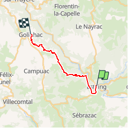

Length
14.6 km

Max alt
665 m

Uphill gradient
593 m
Km-Effort
21 km

Min alt
310 m

Downhill gradient
273 m
Boucle
No
Creation date :
2019-06-21 12:11:12.253
Updated on :
2019-06-21 12:11:53.324
4h40
Difficulty : Very difficult

FREE GPS app for hiking
 SityTrail
IGN / Geographical institutes
SityTrail Plus
The world is yours!
About
Trail Walking of 14.6 km to be discovered at Occitania, Aveyron, Estaing. This trail is proposed by gallo.
Positioning
Country:
France
Region :
Occitania
Department/Province :
Aveyron
Municipality :
Estaing
Location:
Unknown
Start:(Dec)
Start:(UTM)
474023 ; 4933462 (31T) N.
Comments