


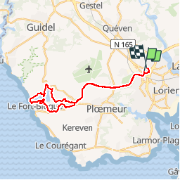
tour etang Lanenech

cl56
User

Length
26 km

Max alt
52 m

Uphill gradient
262 m
Km-Effort
29 km

Min alt
0 m

Downhill gradient
260 m
Boucle
No
Creation date :
2019-06-22 11:57:38.777
Updated on :
2019-06-22 14:23:01.723
2h00
Difficulty : Very easy

FREE GPS app for hiking
 SityTrail
IGN / Geographical institutes
SityTrail Plus
The world is yours!
About
Trail Mountain bike of 26 km to be discovered at Brittany, Morbihan, Lorient. This trail is proposed by cl56.
Positioning
Country:
France
Region :
Brittany
Department/Province :
Morbihan
Municipality :
Lorient
Location:
Unknown
Start:(Dec)
Start:(UTM)
470796 ; 5289743 (30T) N.
Comments