


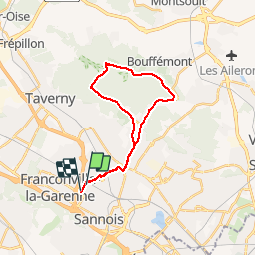
Ermont forêt de Montmorency

csy95
User

Length
22 km

Max alt
200 m

Uphill gradient
281 m
Km-Effort
26 km

Min alt
48 m

Downhill gradient
273 m
Boucle
No
Creation date :
2019-06-23 07:40:27.854
Updated on :
2019-06-23 09:33:45.461
1h52
Difficulty : Very easy

FREE GPS app for hiking
 SityTrail
IGN / Geographical institutes
SityTrail Plus
The world is yours!
About
Trail Road bike of 22 km to be discovered at Ile-de-France, Val-d'Oise, Ermont. This trail is proposed by csy95.
Positioning
Country:
France
Region :
Ile-de-France
Department/Province :
Val-d'Oise
Municipality :
Ermont
Location:
Unknown
Start:(Dec)
Start:(UTM)
445017 ; 5426366 (31U) N.
Comments