


pont de l'abiime gorgés du cheran

papou73
User
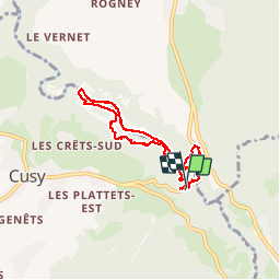

Length
7 km

Max alt
585 m

Uphill gradient
260 m
Km-Effort
10.5 km

Min alt
431 m

Downhill gradient
262 m
Boucle
Yes
Creation date :
2019-06-24 06:48:38.359
Updated on :
2019-06-24 09:23:16.793
2h33
Difficulty : Very easy

FREE GPS app for hiking
 SityTrail
IGN / Geographical institutes
SityTrail Plus
The world is yours!
About
Trail Walking of 7 km to be discovered at Auvergne-Rhône-Alpes, Upper Savoy, Cusy. This trail is proposed by papou73.
Positioning
Country:
France
Region :
Auvergne-Rhône-Alpes
Department/Province :
Upper Savoy
Municipality :
Cusy
Location:
Unknown
Start:(Dec)
Start:(UTM)
270998 ; 5071989 (32T) N.
Comments