


TRACE MESA 27 juin 2019 Sainte-Ode

guy284
User
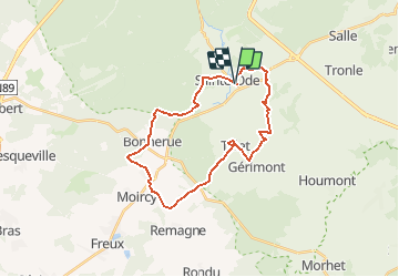

Length
24 km

Max alt
502 m

Uphill gradient
519 m
Km-Effort
31 km

Min alt
368 m

Downhill gradient
517 m
Boucle
Yes
Creation date :
2019-05-28 11:32:37.462
Updated on :
2019-06-24 13:11:41.259
8h57
Difficulty : Very difficult

FREE GPS app for hiking
 SityTrail
IGN / Geographical institutes
SityTrail Plus
The world is yours!
About
Trail Walking of 24 km to be discovered at Wallonia, Luxembourg, Sainte-Ode. This trail is proposed by guy284.
Description
Tracé provisoire
Positioning
Country:
Belgium
Region :
Wallonia
Department/Province :
Luxembourg
Municipality :
Sainte-Ode
Location:
Amberloup
Start:(Dec)
Start:(UTM)
681114 ; 5545536 (31U) N.
Comments