


190624 - Jura.2 - Montépile

randodan
User
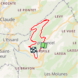

Length
12.1 km

Max alt
1134 m

Uphill gradient
476 m
Km-Effort
18.8 km

Min alt
742 m

Downhill gradient
572 m
Boucle
No
Creation date :
2019-06-24 07:21:29.253
Updated on :
2019-06-25 15:12:16.034
6h16
Difficulty : Medium

FREE GPS app for hiking
 SityTrail
IGN / Geographical institutes
SityTrail Plus
The world is yours!
About
Trail Walking of 12.1 km to be discovered at Bourgogne-Franche-Comté, Jura, Septmoncel les Molunes. This trail is proposed by randodan.
Photos


Positioning
Country:
France
Region :
Bourgogne-Franche-Comté
Department/Province :
Jura
Municipality :
Septmoncel les Molunes
Location:
Septmoncel
Start:(Dec)
Start:(UTM)
723651 ; 5138407 (31T) N.
Comments