


Pic de Bure

GAPIAN43
User

Length
14.7 km

Max alt
2696 m

Uphill gradient
1380 m
Km-Effort
33 km

Min alt
1365 m

Downhill gradient
1383 m
Boucle
Yes
Creation date :
2019-06-26 10:39:48.924
Updated on :
2019-06-28 09:41:48.973
6h21
Difficulty : Difficult

FREE GPS app for hiking
 SityTrail
IGN / Geographical institutes
SityTrail Plus
The world is yours!
About
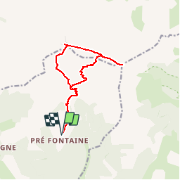
Trail Walking of 14.7 km to be discovered at Provence-Alpes-Côte d'Azur, Hautes-Alpes, Montmaur. This trail is proposed by GAPIAN43.
Description
Montée par la Combe d'Aurouze, descente Combe de Mai
Positioning
Country:
France
Region :
Provence-Alpes-Côte d'Azur
Department/Province :
Hautes-Alpes
Municipality :
Montmaur
Location:
Unknown
Start:(Dec)
Start:(UTM)
730536 ; 4942890 (31T) N.
Comments