


Randonnée usep 2019

nicolas54230
User

Length
11 km

Max alt
423 m

Uphill gradient
242 m
Km-Effort
14.3 km

Min alt
218 m

Downhill gradient
252 m
Boucle
No
Creation date :
2019-06-26 14:46:48.821
Updated on :
2019-06-26 15:21:46.082
36m
Difficulty : Medium

FREE GPS app for hiking
 SityTrail
IGN / Geographical institutes
SityTrail Plus
The world is yours!
About
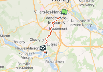
Trail Walking of 11 km to be discovered at Grand Est, Meurthe-et-Moselle, Vandœuvre-lès-Nancy. This trail is proposed by nicolas54230.
Positioning
Country:
France
Region :
Grand Est
Department/Province :
Meurthe-et-Moselle
Municipality :
Vandœuvre-lès-Nancy
Location:
Unknown
Start:(Dec)
Start:(UTM)
292498 ; 5393829 (32U) N.
Comments