


SityTrail - Chamarande

c.chehere
User
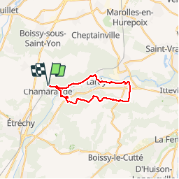

Length
17 km

Max alt
141 m

Uphill gradient
202 m
Km-Effort
19.7 km

Min alt
57 m

Downhill gradient
202 m
Boucle
Yes
Creation date :
2019-06-27 13:49:19.703
Updated on :
2019-06-27 14:05:19.097
4h18
Difficulty : Easy

FREE GPS app for hiking
 SityTrail
IGN / Geographical institutes
SityTrail Plus
The world is yours!
About
Trail Walking of 17 km to be discovered at Ile-de-France, Essonne, Chamarande. This trail is proposed by c.chehere.
Description
Parking au dessus de Chamarande
Positioning
Country:
France
Region :
Ile-de-France
Department/Province :
Essonne
Municipality :
Chamarande
Location:
Unknown
Start:(Dec)
Start:(UTM)
442317 ; 5374149 (31U) N.
Comments