


190627 Sainte Ode

guy284
User
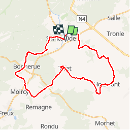

Length
35 km

Max alt
498 m

Uphill gradient
709 m
Km-Effort
44 km

Min alt
369 m

Downhill gradient
708 m
Boucle
Yes
Creation date :
2019-06-27 06:06:09.12
Updated on :
2019-06-27 14:06:53.437
7h56
Difficulty : Difficult

FREE GPS app for hiking
 SityTrail
IGN / Geographical institutes
SityTrail Plus
The world is yours!
About
Trail Walking of 35 km to be discovered at Wallonia, Luxembourg, Sainte-Ode. This trail is proposed by guy284.
Positioning
Country:
Belgium
Region :
Wallonia
Department/Province :
Luxembourg
Municipality :
Sainte-Ode
Location:
Amberloup
Start:(Dec)
Start:(UTM)
681262 ; 5545351 (31U) N.
Comments