


Zakopane

jpgo73
User
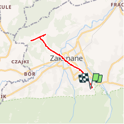

Length
11.1 km

Max alt
1132 m

Uphill gradient
407 m
Km-Effort
16.6 km

Min alt
816 m

Downhill gradient
407 m
Boucle
Yes
Creation date :
2019-06-27 09:12:10.2
Updated on :
2019-06-27 15:17:53.73
5h56
Difficulty : Very easy

FREE GPS app for hiking
 SityTrail
IGN / Geographical institutes
SityTrail Plus
The world is yours!
About
Trail Walking of 11.1 km to be discovered at Lesser Poland Voivodeship, Tatra County. This trail is proposed by jpgo73.
Description
20190626
Positioning
Country:
Poland
Region :
Lesser Poland Voivodeship
Department/Province :
Tatra County
Municipality :
Crocus
Location:
Unknown
Start:(Dec)
Start:(UTM)
424958 ; 5459385 (34U) N.
Comments