


entre-loing-et-orvanne

c.chehere
User
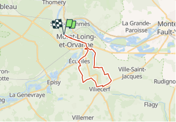

Length
20 km

Max alt
108 m

Uphill gradient
224 m
Km-Effort
23 km

Min alt
46 m

Downhill gradient
223 m
Boucle
Yes
Creation date :
2019-06-28 12:00:25.365
Updated on :
2023-06-25 16:38:05.549
5h18
Difficulty : Very difficult

FREE GPS app for hiking
 SityTrail
IGN / Geographical institutes
SityTrail Plus
The world is yours!
About
Trail Walking of 20 km to be discovered at Ile-de-France, Seine-et-Marne, Moret-Loing-et-Orvanne. This trail is proposed by c.chehere.
Description
Fiche explicative FFRP77
Parking groupe scolaire Ravanne
Positioning
Country:
France
Region :
Ile-de-France
Department/Province :
Seine-et-Marne
Municipality :
Moret-Loing-et-Orvanne
Location:
Veneux-les-Sablons
Start:(Dec)
Start:(UTM)
485169 ; 5358357 (31U) N.
Comments