


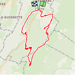
Crêtes du parc naturel régional du Haut-Jura

mpstoop
User


4h55
Difficulty : Very difficult

FREE GPS app for hiking
 SityTrail
IGN / Geographical institutes
SityTrail Plus
The world is yours!
About
Trail Walking of 20 km to be discovered at Auvergne-Rhône-Alpes, Ain, Lélex. This trail is proposed by mpstoop.
Description
Ascension au depart de LELEX (01) sur le Grand -Crêt, suivie d'un parcourt en crête jusqu'au Reculet - 1719 m -
Trajet aerien et sauvage entre deux panoramas, à l'Est sur le lac Léman et la Suisse, à l'Ouest sur le Jura français .
Chaos rocheux, ravins éboulis et falaises abritent une faune et flore montagnardes d'une richesse inégalable .
Positioning
Comments