


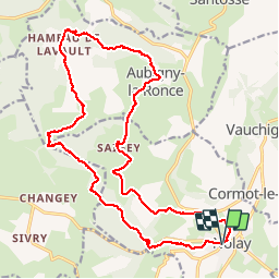
Nolay Lavault Saigey 07-2019

Kargil
User GUIDE

Length
21 km

Max alt
492 m

Uphill gradient
512 m
Km-Effort
28 km

Min alt
319 m

Downhill gradient
512 m
Boucle
Yes
Creation date :
2019-06-30 06:05:26.095
Updated on :
2019-07-02 19:58:03.027
5h40
Difficulty : Medium

FREE GPS app for hiking
 SityTrail
IGN / Geographical institutes
SityTrail Plus
The world is yours!
About
Trail Walking of 21 km to be discovered at Bourgogne-Franche-Comté, Côte-d'Or, Nolay. This trail is proposed by Kargil.

Positioning
Country:
France
Region :
Bourgogne-Franche-Comté
Department/Province :
Côte-d'Or
Municipality :
Nolay
Location:
Unknown
Start:(Dec)
Start:(UTM)
624058 ; 5201050 (31T) N.
Comments