


pic de tarbesou

82240gerard
User
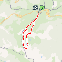

Length
10.8 km

Max alt
2351 m

Uphill gradient
693 m
Km-Effort
20 km

Min alt
1927 m

Downhill gradient
694 m
Boucle
Yes
Creation date :
2019-06-30 06:12:08.51
Updated on :
2019-06-30 12:24:03.416
6h10
Difficulty : Medium

FREE GPS app for hiking
 SityTrail
IGN / Geographical institutes
SityTrail Plus
The world is yours!
About
Trail Walking of 10.8 km to be discovered at Occitania, Ariège, Ascou. This trail is proposed by 82240gerard.
Description
randonnée pédestre
Positioning
Country:
France
Region :
Occitania
Department/Province :
Ariège
Municipality :
Ascou
Location:
Unknown
Start:(Dec)
Start:(UTM)
417216 ; 4731518 (31T) N.
Comments