


GTDV J1

PhilippeC54
User
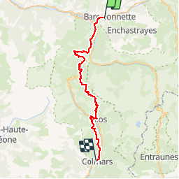

Length
43 km

Max alt
2359 m

Uphill gradient
1733 m
Km-Effort
66 km

Min alt
1124 m

Downhill gradient
1612 m
Boucle
No
Creation date :
2019-06-30 06:46:28.471
Updated on :
2019-06-30 19:41:37.47
6h11
Difficulty : Difficult

FREE GPS app for hiking
 SityTrail
IGN / Geographical institutes
SityTrail Plus
The world is yours!
About
Trail Mountain bike of 43 km to be discovered at Provence-Alpes-Côte d'Azur, Alpes-de-Haute-Provence, Barcelonnette. This trail is proposed by PhilippeC54.
Positioning
Country:
France
Region :
Provence-Alpes-Côte d'Azur
Department/Province :
Alpes-de-Haute-Provence
Municipality :
Barcelonnette
Location:
Unknown
Start:(Dec)
Start:(UTM)
312143 ; 4917174 (32T) N.
Comments