


L Tour de Meriel

avdem
User
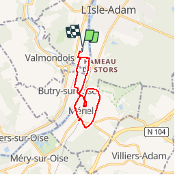

Length
9.4 km

Max alt
67 m

Uphill gradient
89 m
Km-Effort
10.6 km

Min alt
22 m

Downhill gradient
88 m
Boucle
Yes
Creation date :
2019-07-01 07:36:31.414
Updated on :
2019-07-01 10:12:45.087
2h35
Difficulty : Very easy

FREE GPS app for hiking
 SityTrail
IGN / Geographical institutes
SityTrail Plus
The world is yours!
About
Trail Walking of 9.4 km to be discovered at Ile-de-France, Val-d'Oise, Parmain. This trail is proposed by avdem.
Description
très cool
Positioning
Country:
France
Region :
Ile-de-France
Department/Province :
Val-d'Oise
Municipality :
Parmain
Location:
Unknown
Start:(Dec)
Start:(UTM)
442000 ; 5438729 (31U) N.
Comments