


20180215-La_Croix_du_Thil

doudet
User
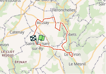

Length
14.2 km

Max alt
166 m

Uphill gradient
229 m
Km-Effort
17.2 km

Min alt
81 m

Downhill gradient
230 m
Boucle
Yes
Creation date :
2019-07-02 06:27:13.279
Updated on :
2019-07-02 06:27:13.279
--
Difficulty : Unknown

FREE GPS app for hiking
 SityTrail
IGN / Geographical institutes
SityTrail Plus
The world is yours!
About
Trail Walking of 14.2 km to be discovered at Normandy, Seine-Maritime, Saint-Aignan-sur-Ry. This trail is proposed by doudet.
Positioning
Country:
France
Region :
Normandy
Department/Province :
Seine-Maritime
Municipality :
Saint-Aignan-sur-Ry
Location:
Unknown
Start:(Dec)
Start:(UTM)
380706 ; 5484721 (31U) N.
Comments